At Bonefish & Tarpon Trust, we know conserving habitat is the best way to conserve our fisheries. And the most meaningful impacts are large-scale and science-based. For more than 50 years, the National Oceanic and Atmospheric Administration (NOAA) has supported this approach through the National Estuarine Research Reserve System, a network of 30 sites designated to protect and study coastal environments around the United States.
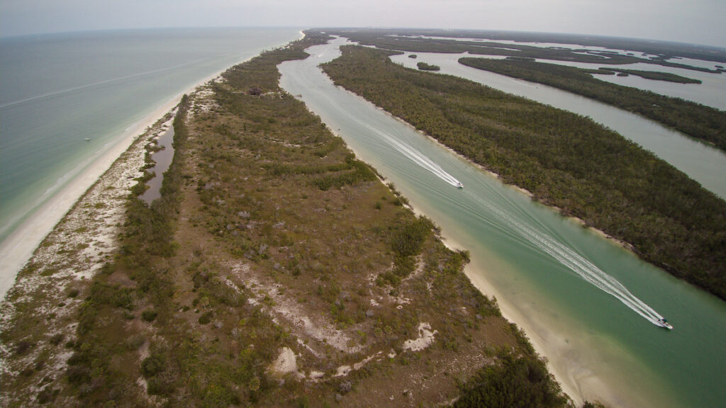
In Southwest Florida, the Rookery Bay Reserve—managed in partnership by NOAA and the Florida Department of Environmental Protection (FDEP)—protects nearly 40% of Collier County’s coastline and one of the last remaining undisturbed mangrove estuaries in North America. Spanning 110,000 acres of mangrove forest, upland, and open water, Rookery Bay is a critical nursery for snook, tarpon, redfish, and other iconic gamefish species.

“For anglers, Reserves like Rookery Bay do much more than protect places to fish—they monitor them, conduct research, and partner to restore the habitats that bonefish, tarpon, and other sportfish rely on,” says Rebecca Roth, the executive director of the National Estuarine Research Reserve Association (NERRA). “Seventy-five percent of all fish caught begin their life in the nursery grounds of an estuary; when you protect these waters and the lands surrounding them, you protect the nursery.”
The Reserve System has set a standard for environmental monitoring, which is key to habitat restoration and conservation. Since 1992, Reserves have amassed a unique national dataset that provides a record of how coastal weather, water quality, sea levels, habitat, and vegetation have changed over time. These have all been collected, synthesized, and analyzed according to stringent standards that have been emulated throughout Florida and around the country.
“Reserves were created in 1972 to track short-term changes and long-term trends on our coasts,” says Roth. “Today, the Reserve System is the only national network of protected places with standardized estuary monitoring, integrated science and education, and deep local partnerships. The high-quality data they produce is trusted by communities, and used by fisheries managers, businesses, scientists, and others to respond to challenges today and in the future.”
Reserve education, community engagement, and training programs ensure that research and data from Reserves are accessible and meaningful to local communities. These programs highlight the importance of habitat conservation for people of all ages—reaching more than 73,000 K–12 students in 2022 alone—and support citizen science initiatives and volunteer cleanup efforts that foster public involvement and care for the land and water.
All of this activity is a boon for local and state economies. Florida’s three Reserves—which include Rookery Bay, Guana Tolomato Matanzas, and Apalachicola—help protect and manage 418,000+ acres of coastal lands and waters that provide many valuable benefits to Florida’s economy. For example, in 2020, they enhanced local revenues by $45 million through investments in staff salaries, facilities maintenance, and operations.
Restoring freshwater flow to the Rookery Bay estuary has been a decades-long, collaborative effort, involving NOAA, the State of Florida, nonprofit partners, and local communities. Through this work, the Reserve has removed outdated roads, installed culverts, and replanted mangrove wetlands—leading to better water quality, stronger fisheries, and thriving ecotourism.
Today, Bonefish & Tarpon Trust is building on this foundation by partnering with Ducks Unlimited (DU), the Florida Department of Environmental Protection (FDEP), and the Miccosukee Tribe of Indians to complete two hydrologic restoration projects within the Reserve on Shell Island and Marco Shores. Despite past successes, key coastal wetlands in Rookery Bay remain threatened by man-made alterations—such as roads and infrastructure—that disrupt natural water flow. These disruptions are degrading mangrove and marsh ecosystems, compromising fish habitat, increasing ecosystem vulnerability, and diminishing the region’s resilience to storm surge and sea level rise.
These projects will increase natural tidal flows to habitats essential to juvenile sportfish, while improving water quality and increasing resilience from storm impacts to neighboring communities. The first phase—habitat assessment and preliminary design—was completed in 2024 and final design and permitting are underway. This work was partially funded through Florida Legislative Grants and the National Fish and Wildlife Foundation grants program. The project partners have applied for federal funding for the final phase, construction. This award will be announced at the end of 2025.
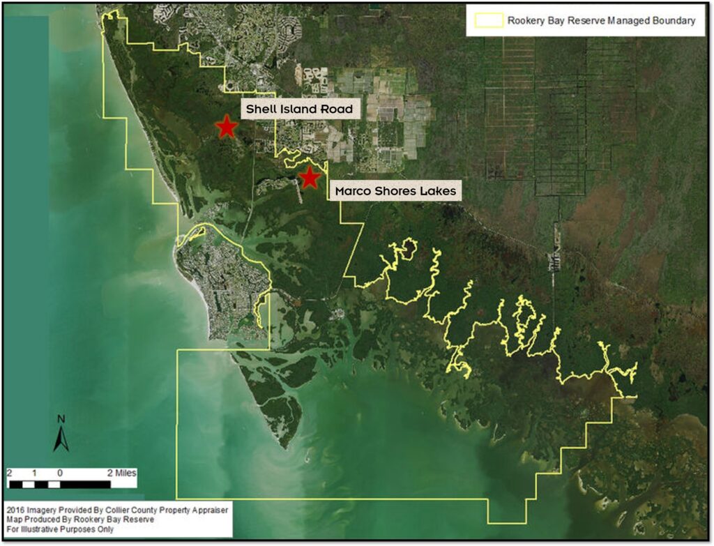
The two projects that BTT, DU, and RBNERR are working on are called Shell Island Road and Marco Shores. The Shell Island site includes a three-mile asphalt road that ends in a primitive boat ramp into Rookery Bay. The roadway has restricted the natural tidal flow from the bay and altered freshwater flows from upland areas. This has isolated mangrove and marsh swamps. The restoration project will install culverts under the roads to allow better water flows, and wildlife crossings in the upland areas will allow tidal passage and migration pathways for aquatic and terrestrial species.

At Marco Shores, a water control structure has impeded water flow from Marco Shores Lake to a tidal creek feeding McIlvane Bay. For this restoration, we will adjust the structure to allow for emigration of sportfish without compromising water levels of the lake for residents. We know from our research in Indian River Lagoon mosquito impoundments that by adjusting the weir passage during short periods in the fall during emigration, tarpon will be able to enter the lake as larvae and leave the lake as juveniles, and contribute to the regional tarpon population.
These restoration projects are part of a larger regional plan that builds on a Rookery Bay Reserve-led project to understand the impacts of altered freshwater flows to the estuary and improve watershed management. They dovetail with other proposed hydrologic restoration work both in- and off-Reserve, including Collier-Seminole State Park, Ten Thousand Islands National Wildlife Refuge, Conservation Collier, Fakahatchee Strand Preserve State Park, Big Cypress National Preserve, Everglades National Park, Crocodile Lake National Wildlife Refuge, and Biscayne National Park. This collective of projects seek to restore the natural sheet-flow of the Greater Everglades system and enhance hydrologic connectivity within the largest contiguous mangrove forest in the United States.
Reserves like Rookery Bay are supported through a unique state–federal partnership that brings NOAA’s expertise and resources to meet the needs of coastal communities. NOAA provides federal funding and technical assistance, while state partners contribute matching funds and oversee Reserve operations. This partnership was established by Congress and signed into law in 1972 through the Coastal Zone Management Act (CZMA), which set national policy to “preserve, protect, develop, and where possible, to restore or enhance the resources of the Nation’s coastal zone.”
“Congress, through the CZMA, laid the foundation for the Reserve System,” says Roth. “By design it’s a federal–state partnership that really works—government done right. Combined with a strong support group like Friends of Rookery Bay—it’s what makes large-scale watershed restoration efforts like those in Collier County possible.”
That’s one reason NERRA, BTT, and many other national organizations are supporting the Resilient Coasts and Estuaries Act. This vital legislation would reauthorize and expand the Reserve System and the Coastal and Estuarine Land Conservation Program. It would also direct NOAA to designate five new Reserves, expanding the acreage of protected estuarine habitat and increasing opportunities for angling, public access, and recreation, while creating more habitat for fisheries and supporting the coastal economies that depend on healthy ecosystems.
As stewards of our fisheries, we must be persistent in advocating for habitat conservation and programs that protect those habitats.